Page 25 - MRT - Visitor Guide Hyperlinks3
P. 25
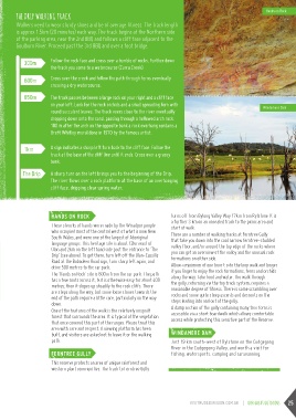
THE DRIP WALKING TRACK Hands on Rock
Walkers need to wear sturdy shoes and be of average fitness. The track length Windamere Dam
is approx 1.5km (20 minutes) each way. The track begins at the Northern side
of the parking area, near the 2nd BBQ and follows a cliff face adjacent to the
Goulburn River. Proceed past the 3rd BBQ and over a foot bridge.
Follow the rock face and cross over a tumble of rocks. Further down
the track you come to a watercourse (Curra Creek).
300m
600m Cross over the creek and follow the path through ferns eventually
crossing a dry watercourse.
850m The track passes between a large rock on your right and a cliff face
on your left. Look for the rock orchids and a small spreading fern with
round succulent leaves. The track veers close to the river eventually
dropping down onto the sand, passing through a hollowed arch rock.
100 m after the arch on the opposite bank a rock overhang contains a
Brett Whitley mural done in 1970 by the famous artist.
1km A sign indicates a sharp left turn back to the cliff face. Follow the
The Drip track at the base of the cliff line until it ends. Cross over a grassy
bank.
A sharp turn on the left brings you to the beginning of the Drip.
The river flows over a rock platform at the base of an overhanging
cliff face, dripping clear spring water.
HANDS ON ROCK turns off from Bylong Valley Way 17km from Rylstone. It is
These stencils of hands were made by the Wiradjuri people a further 3 km on an unsealed track to the picnic area and
who occupied most of the central west of what is now New start of walk.
South Wales, and were one of the largest of Aboriginal There are a number of walking tracks at Ferntree Gully
language groups. This heritage site is about 12km east of that take you down into the cool narrow ferntree-studded
Ulan and 2km on the left hand side past the entrance to ‘The valley floor, and/or around the top edge of the rocks where
Drip’ (see above). To get there, turn left off the Ulan-Cassilis you can get an overview of the valley and the unusual rock
Road at the Bobadeen Road sign, turn sharp left again, and formations on either side.
drive 500 metres to the car park. Allow a minimum of one hour t o do the loop walk and longer
The ‘Hands on Rock’ site is 600m from the car park. The path if you linger to enjoy the rock formations, ferns and orchids
has a few roots across it, but is otherwise easy for about 400 along the way. Take food and water. The walk through
metres; then it slopes up steadily to the rock cliffs. There the gully, returning via the top track system, requires a
are steps along the way, but some loose stones towards the reasonable degree of fitness. There is some scrambling over
end of the path require a little care, particularly on the way rocks and some quite steep ascents and descents on the
down. steps leading into and out of the gully.
One of the features of the walk is the relatively unspoilt A damp section of the gully containing many tree ferns is
forest that surrounds the area. It is typical of the vegetation accessible via a short boardwalk which allows comfortable
that once covered this part of the ranges. Please treat this access while protecting this sensitive part of the Reserve.
area with care and respect. A viewing platform has been
built, and visitors are asked not to leave it or the walking WINDAMERE DAM
path. Just 19 km south-west of Rylstone on the Cudgegong
River in the Cudgegong Valley, and worth a visit for
FERNTREE GULLY fishing, watersports, camping and caravanning.
This reserve protects an area of unique rainforest and
western plant communities. The track to Ferntree Gully
VISITMUDGEEREGION.COM.AU | our great outdoors 25